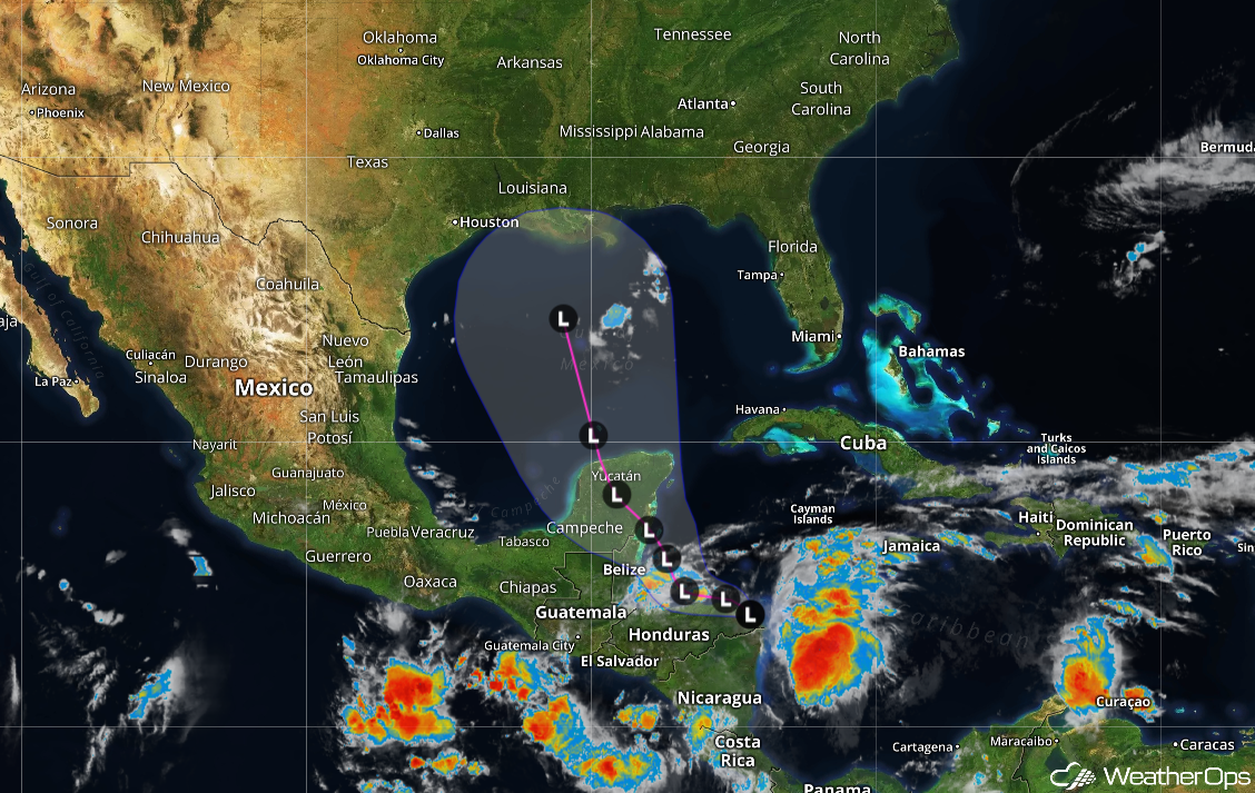
Atlantic Ocean Temperature Records
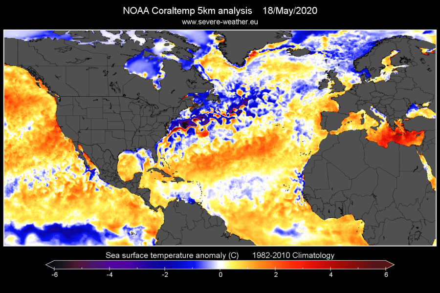
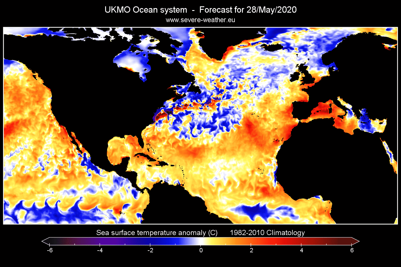
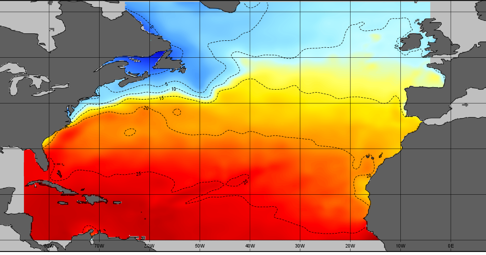
The North Atlantic is experiencing an unusual cooling trend in the Gulf Stream. This has been attributed to the presence of low-pressure systems that are bringing colder air into the region. It is important to analyze this phenomenon as it can have significant implications for weather patterns and sea temperature anomalies.
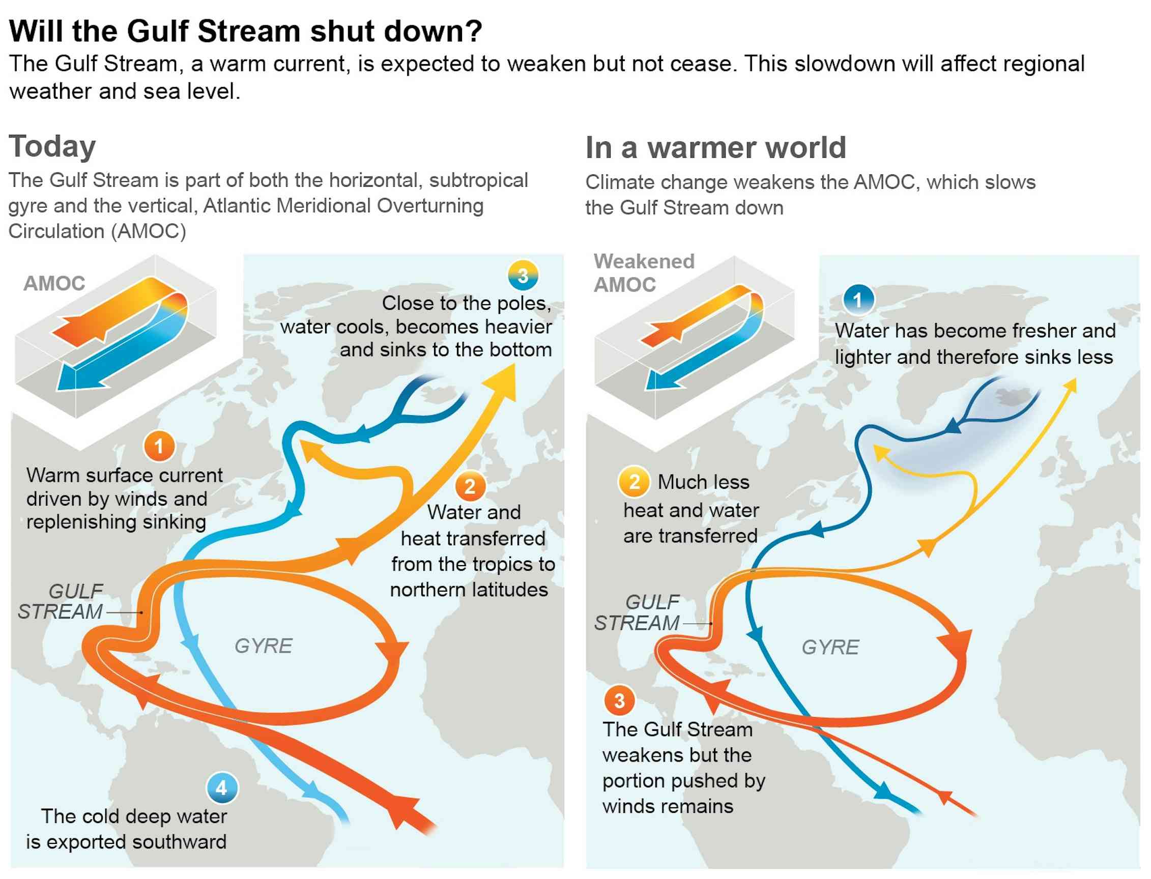
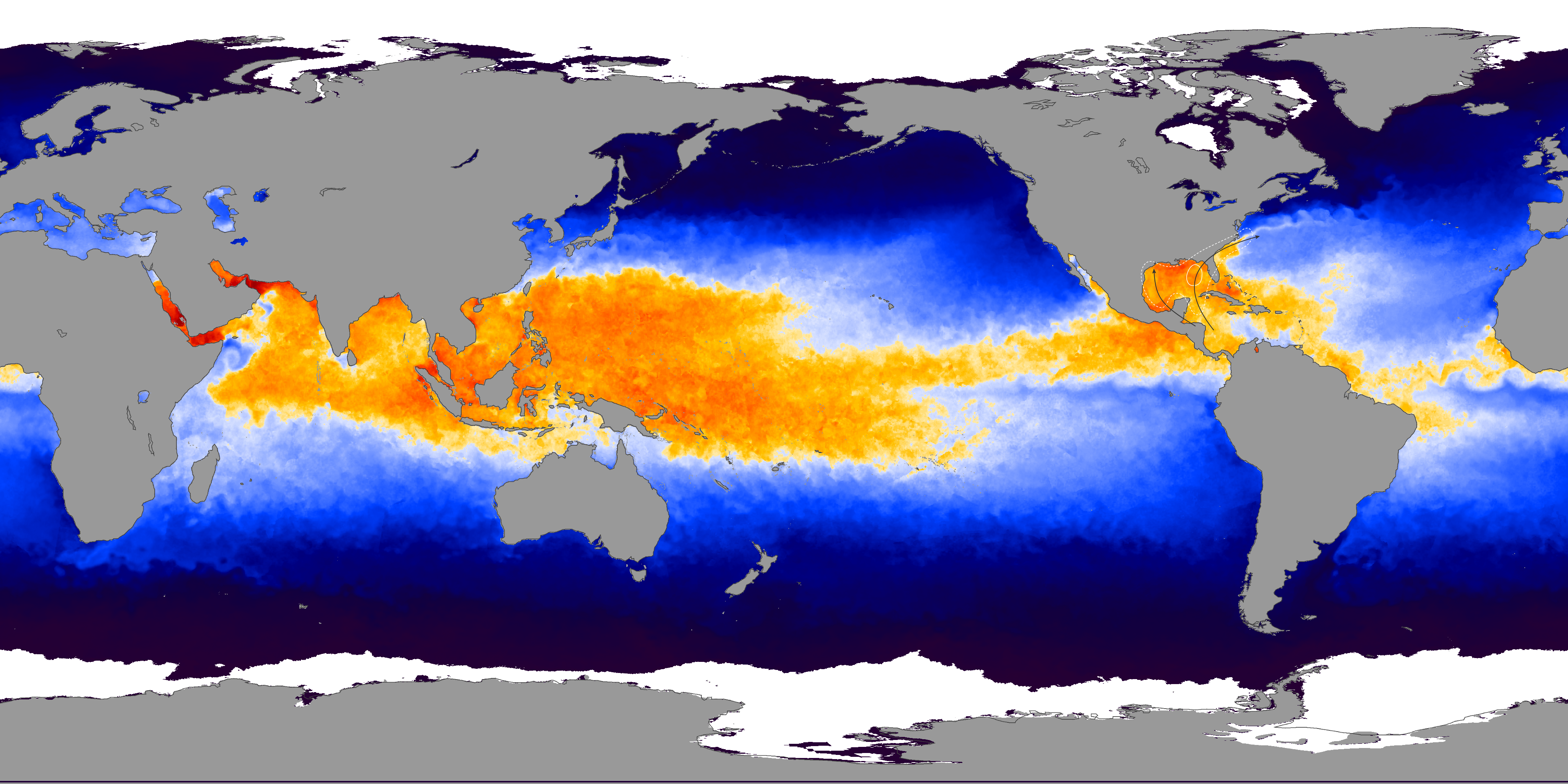
The Gulf Stream is a strong ocean current that originates in the Gulf of Mexico, flows along the eastern coast of the United States, and eventually splits into several branches. It is a key component of the Atlantic Meridional Overturning Circulation (AMOC), which plays a crucial role in the global climate system. The AMOC helps distribute heat, salt, and nutrients around the world's oceans, impacting both marine and atmospheric conditions.
The Impact of Low-Pressure Systems
Low-pressure systems are characterized by atmospheric conditions in which the pressure at a given location is lower than its surroundings. They are typically associated with unsettled weather, including cloud formation and precipitation. In the case of the North Atlantic, these low-pressure systems have caused a cooling effect on the Gulf Stream.
1. Disruption of Oceanic Currents: The presence of low-pressure systems can disrupt the normal flow of ocean currents, causing changes in temperature and salinity. As a result, the Gulf Stream, known for its warm and swift waters, is experiencing a cooling trend.
2. Alteration of Heat Transfer: The Gulf Stream plays a significant role in transferring heat from the tropics to higher latitudes, impacting climate and weather patterns along its path. With the cooling effect caused by the low-pressure systems, the transfer of heat is disrupted, potentially leading to deviations in regional and global weather patterns.
The Importance of Sea Temperature Anomalies
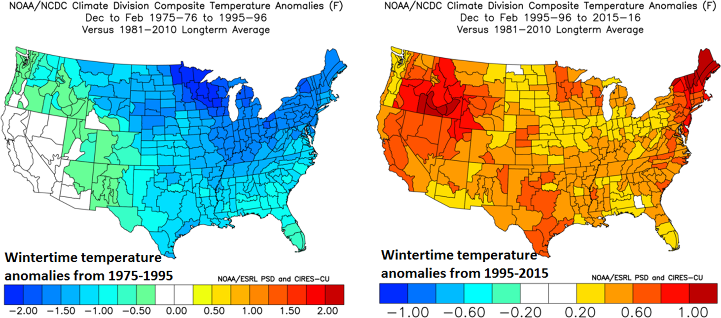
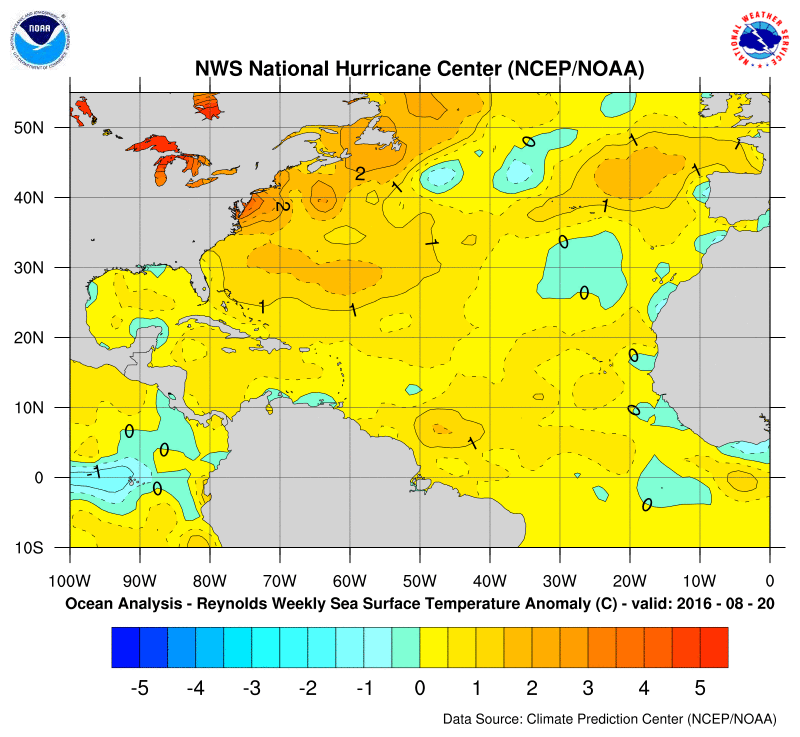
Sea temperature anomalies refer to deviations from the average surface temperatures of a particular body of water. Monitoring these anomalies is crucial for understanding climate dynamics, identifying the presence of El Niño or La Niña events, and predicting extreme weather conditions.
1. Impact on Marine Ecosystems: Sea temperature anomalies can have profound effects on marine ecosystems, including changes in the distribution of marine species, alterations in the timing of reproduction and migration, and shifts in food availability. These changes can disrupt the delicate balance of ecosystems and impact the livelihoods of communities dependent on marine resources.
2. Influence on Atmospheric Conditions: Changes in sea surface temperatures can also affect atmospheric conditions. Warmer ocean temperatures can fuel the formation of tropical storms and hurricanes, while cooler temperatures can suppress their development. Understanding sea temperature anomalies is essential for accurate weather forecasting and early warning systems.
Benefits and Advantages
Recognizing and analyzing the unusual cooling of the Gulf Stream in the North Atlantic brings several benefits and advantages:
1. Improved Climate Modeling: By studying sea temperature anomalies and their causes, scientists can refine climate models to better predict long-term climate trends and evaluate the impact of various factors on the Earth's climate system.
2. Early Warning Systems: Monitoring sea temperature anomalies can contribute to the development of early warning systems for extreme weather events, such as hurricanes, which can help authorities and communities prepare and mitigate the potential impact.
The Conclusion
In conclusion, the Gulf Stream's unusual cooling in the North Atlantic, caused by low-pressure systems bringing colder air into the region, is an important phenomenon to analyze. Understanding the impact of these changes on oceanic currents, heat transfer, marine ecosystems, and atmospheric conditions is essential for climate modeling, weather forecasting, and the well-being of coastal communities.
It is crucial to continue monitoring and studying sea temperature anomalies to gain a deeper understanding of the Earth's climate system and its potential consequences. By doing so, we can enhance our ability to predict and mitigate the impact of extreme weather events and make informed decisions to protect both the environment and human livelihoods.
People Also Ask:
Q: How do low-pressure systems affect the Gulf Stream?
A: Low-pressure systems can disrupt the normal flow of ocean currents, leading to changes in temperature and salinity. In the case of the Gulf Stream, the presence of low-pressure systems has caused a cooling trend.
Q: Why are sea temperature anomalies important?
A: Sea temperature anomalies are crucial for understanding climate dynamics, predicting extreme weather conditions, and assessing the health of marine ecosystems. They provide valuable information for climate modeling and early warning systems.
If you are searching about Mapped: Global temperatures since 1880 | Map, Infographic you've visit to the right web. We have 25 Pics about Mapped: Global temperatures since 1880 | Map, Infographic like Atlantic Ocean Temperatures at End of June 2009, Current Ocean Temperature Map and also Current Ocean Temperature Map. Read more:
Mapped: Global Temperatures Since 1880 | Map, Infographic
 www.pinterest.com
 atlantic axios
2:15 PM | *Atlantic Ocean Showing Early Signs Of A Significant Long-term Shift In Temperatures
 www.perspectaweather.com
 atlantic ocean shift significant temperatures term warm cold showing signs pm long temperature climate early
12:30 PM | The Atlantic Ocean Is Showing Signs Of A Possible Significant Long-term Shift In
 www.vencoreweather.com
 shift significant temperatures term possible warm cold showing signs long
Atlantic Tropical Season Heating Up – Finger Lakes Weather
 flxweather.com
 atlantic sst sea surface temperature ocean anomaly analysis north temperatures weather noaa charts tropical heating season anomalies nhc meteorological water
Water Temperature In Atlantic Ocean In July
 seatemperature.info
 bordering countries
Pressure Changes In The North Atlantic Start A Strong Ocean Warming Event, With Known Historical
 www.severe-weather.eu
 ocean
Current Ocean Temperature Map
 countmap.blogspot.com
 atlantic temperature hurricane current outlook ocean water map tidbits maps temperatures
Current Ocean Temperature Map
 countmap.blogspot.com
 ocean atlantic sea temperatures temperature map current maps
Atlantic Ocean Water Temperature Map
 mapingonlinesource.blogspot.com
 temperature water atlantic ocean map affect tropical systems does
The Atlantic Ocean Is Packed With Storms. What's Going On?
 mashable.com
 atlantic storms temperatures surface mashable
Atlantic Ocean Temperatures - Stock Image - V660/0028 - Science Photo Library
 www.sciencephoto.com
 *North Atlantic* The Gulf Stream Cools Unusually, As Low-pressure Systems Bring Colder Air Out
 www.severe-weather.eu
 anomaly
Profound Changes Are Underway In Earth’s Oceans And Ice – A Lead Climate Report Author Explains
 minnesotareformer.com
 ipcc gulf meridional circulation overturning oceans profound underway august warnings slowdown tipping dernier undergoing warning theconversation
Pressure Changes In The North Atlantic Start A Strong Ocean Warming Event, With Known Historical
 www.severe-weather.eu
 northwestern weaker anomalies subtropical
Water Temperatures In The Atlantic Ocean, January 2020. | Water Temperature, Atlantic Ocean, Ocean
 www.pinterest.com
 ocean
Climate4you OceanTemperaturesAndSeaLevel
 www.climate4you.com
 climate4you depth north transect atlantic 2000
The Trend And Variability Of Tropical Atlantic Sea Surface Temperature... | Download Scientific
 www.researchgate.net
 variability sst spatial
*North Atlantic* The Gulf Stream Cools Unusually, As Low-pressure Systems Bring Colder Air Out
www.severe-weather.eu colder impacting cools unusually anomaly
How Is Climate Change Affecting The Atlantic Ocean? | World Economic Forum
 www.weforum.org
 atlantic ocean temperature research decade hottest
27 Atlantic Ocean Temperature Map - Maps Online For You
 consthagyg.blogspot.com
 temperature
Atlantic Ocean Temperatures At End Of June 2009
 earthobservatory.nasa.gov
 ocean atlantic temperatures 2009 june end
Maps Of Temperature In The North Atlantic Ocean At 200 M Depth In... | Download Scientific Diagram
 www.researchgate.net
 temperature
Maps Of The Sea Surface Temperatures In The Atlantic Ocean During... | Download Scientific Diagram
 www.researchgate.net
 temperatures seawater
2:15 PM | *Atlantic Ocean Showing Early Signs Of A Significant Long-term Shift In Temperatures
 www.perspectaweather.com
 ocean atlantic temperature shift significant temperatures term warm cold showing signs long surface sea early pm represented normal reds yellows
SeaDataCloud North Atlantic Ocean Temperature And Salinity Climatology V1
 sextant.ifremer.fr
 atlantic ocean
Maps of temperature in the north atlantic ocean at 200 m depth in.... Atlantic tropical season heating up – finger lakes weather. Current ocean temperature map


Comments
Post a Comment