Atlantic Ocean Surface Temperature Chart

The Atlantic Ocean surface temperature plays a crucial role in understanding weather patterns and climate changes in the region. As the vast expanse of water that covers a significant part of the Earth, any shifts or variations in its temperature can have far-reaching effects on marine life, weather systems, and even global climate patterns. In this post, we will explore the SST (Sea Surface Temperature) of the Atlantic Ocean, specifically focusing on the data provided by METEOSAT-11.
The SST - Atlantic Ocean surface temperature data provided by METEOSAT-11 offers valuable insights into the current state of the ocean and helps scientists and researchers monitor its changes over time. With this data, meteorologists can accurately predict and analyze weather conditions, identify potential storm formations, and understand the impact of climate change on the Atlantic region.
Understanding the SST - Atlantic Ocean Surface Temperature
The Atlantic Ocean is one of the world's major oceans, covering approximately 20% of the Earth's surface. Its surface temperature plays a critical role in shaping the climate and weather systems in the surrounding regions. The SST - Atlantic Ocean surface temperature refers to the measurement of the upper layer of water's temperature, primarily influenced by solar radiation and atmospheric conditions. This data helps scientists understand various climatic phenomena such as El Niño, La Niña, and the Atlantic Multidecadal Oscillation.
Factors Affecting Atlantic Ocean Surface Temperature
The SST of the Atlantic Ocean is influenced by several factors, including:
- Ocean currents: The movement of ocean currents affects the distribution of warm and cold water, thus impacting the surface temperature. For instance, the Gulf Stream transports warm water from the Gulf of Mexico to the Atlantic Ocean, leading to higher temperatures in certain regions.
- Solar radiation: The amount of sunlight reaching the ocean's surface influences its temperature. Regions closer to the equator receive more direct sunlight, resulting in higher SST.
- Atmospheric conditions: Factors like air temperature, humidity, and wind patterns affect the ocean's surface temperature. For example, prevailing winds can cause upwelling, bringing cooler waters to the surface.
- Climate patterns: Long-term climate patterns such as the Atlantic Multidecadal Oscillation can cause variations in the ocean's temperature. These patterns can last for several decades, contributing to changes in regional climate and weather systems.
Importance of Monitoring Atlantic Ocean Surface Temperature
Monitoring the SST - Atlantic Ocean surface temperature is crucial for various reasons:
- Weather forecasting: Accurate knowledge of the surface temperature helps meteorologists predict and understand weather conditions in the Atlantic region. This information enables them to issue timely warnings for storms, hurricanes, and other potentially hazardous weather events.
- Climate studies: The Atlantic Ocean plays a significant role in global climate patterns, and changes in its temperature can impact weather systems worldwide. By monitoring SST data, scientists can track and study climate change trends, enabling better predictions and mitigation strategies.
- Marine ecosystems: Marine life is highly dependent on specific temperature conditions. Understanding the SST helps marine biologists identify areas that are ideal for certain species, study migration patterns, and assess potential impacts on marine ecosystems due to temperature changes.
- Fishing industry: The fishing industry relies heavily on the ocean's temperature data to identify regions with suitable conditions for different fish species. This information aids in making informed decisions related to fishing practices and sustainable resource management.
Benefits and Advantages of SST Data from METEOSAT-11
The SST data provided by METEOSAT-11 offers several benefits and advantages:
- Real-time monitoring: METEOSAT-11 continuously collects and provides up-to-date data on the Atlantic Ocean surface temperature. This allows scientists and researchers to monitor changes in real-time, enhancing their ability to understand and predict weather patterns.
- High-resolution imagery: The SST data from METEOSAT-11 includes high-resolution imagery, providing detailed observations of the Atlantic Ocean's surface. This level of detail enables accurate analysis and precise identification of temperature variations across different regions.
- Long-term data records: METEOSAT-11 maintains a comprehensive database of SST records, allowing for long-term climate studies and trend analysis. The accumulated data over time provides valuable insights into the ocean's temperature patterns, aiding in climate change research.
Conclusion
In conclusion, the SST - Atlantic Ocean surface temperature data from METEOSAT-11 is a valuable resource for understanding and monitoring the temperature variations in the region. The data enables scientists, meteorologists, and researchers to make accurate predictions about weather conditions, study climate change trends, and assess impacts on marine ecosystems. By leveraging this information, we can continue to improve our understanding of the Atlantic Ocean and its vital role in shaping the Earth's climate.
People Also Ask
What are the effects of Atlantic Ocean surface temperature on hurricanes?
The Atlantic Ocean's surface temperature significantly influences hurricane formation and intensity. Warmer ocean temperatures provide the necessary energy for hurricanes to develop and strengthen. When the surface temperature is above a certain threshold, tropical disturbances can form, potentially leading to hurricanes.
How does the Atlantic Multidecadal Oscillation affect the SST?
The Atlantic Multidecadal Oscillation (AMO) refers to the natural cyclical variation in the North Atlantic Ocean's surface temperature. During the positive phase of the AMO, the SST in the Atlantic tends to be warmer, while the negative phase corresponds to cooler temperatures. This phenomenon can last for several decades and affects climate patterns, including hurricane activity and regional weather conditions.
If you are looking for Main ocean currents and sea surface temperatures in the North Atlantic... | Download Scientific you've came to the right web. We have 25 Pics about Main ocean currents and sea surface temperatures in the North Atlantic... | Download Scientific like Correcting historic sea surface temperature measurements | EurekAlert! Science News, Global-Atlantic Surface Temperature on Friday 17 Sep at 12pm UTC and also How Does Water Temperature Affect Tropical Systems?. Read more:
Main Ocean Currents And Sea Surface Temperatures In The North Atlantic... | Download Scientific
 www.researchgate.net
 currents
Average Sea Surface Temperature In The North Atlantic For A) July 2017... | Download Scientific
 www.researchgate.net
 Water Temperature In Atlantic Ocean Today
 seatemperature.info
 bordering temp seatemperature
Climate Signals | Map: Atlantic Sea Surface Temperature Anomaly, September 4, 2017
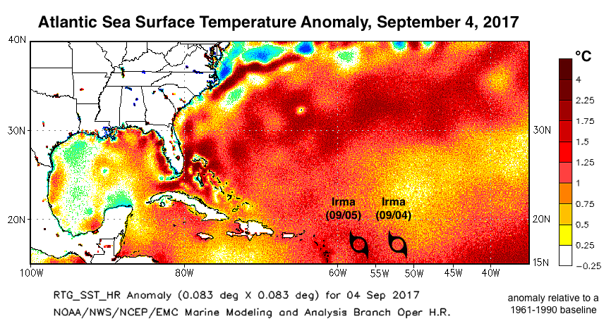 www.climatesignals.org
 surface sea temperature anomaly atlantic irma map september temperatures sept baseline amid ranging rapidly intensified between climatesignals resources
Atlantic Sea Surface Temperature Anomaly
 earthobservatory.nasa.gov
 sea surface atlantic temperature anomaly nasa sst ocean oceans gov 2006
Sea Surface Temperature – Use Due Diligence On… Climate
 use-due-diligence-on-climate.org
 sea temperature surface climate north diligence due use climate4you temperatures global
Mapped: Global Temperatures Since 1880 | Map, Infographic
 www.pinterest.com
 atlantic axios
Current Sea Temp Image North
 www.maineharbors.com
 noaa sst north temperature sea atlantic contour surface current data ocean chart pacific temp charts west satellite office gulf weather
Climate Signals | Map: Atlantic Sea Surface Temperature Anomaly, August 23, 2017
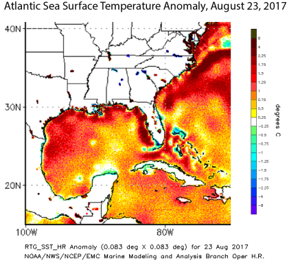 www.climatesignals.org
 sea surface temperature map mexico august gulf harvey atlantic anomaly temperatures climatesignals resources average climate
Annual North Atlantic Sea Surface Temperatures Between 18562017. The... | Download Scientific
Ocean Temperatures: Is That Warming Statistically Significant? - The Global Warming Policy Forum
 www.thegwpf.com
 ocean warming temperatures rise global temperature statistically significant graph graphs error convincingly bars enough huge even looks but
Surface Temperature And Heat Transport In The North Atlantic Ocean. The... | Download Scientific
 www.researchgate.net
 relatively
Correcting Historic Sea Surface Temperature Measurements | EurekAlert! Science News
 eurekalert.org
 temperature sea surface ocean chart atlantic north pacific changes warming data annual shows datasets different scientists bottom simpler pattern eurekalert
Current Ocean Temperature Map
 countmap.blogspot.com
 ocean atlantic sea temperatures temperature map current maps
SST - Atlantic Ocean Surface Temperature (METEOSAT-11)
 planeta.infospace.ru
 sst ocean planeta
Maps Of The Sea Surface Temperatures In The Atlantic Ocean During... | Download Scientific Diagram
 www.researchgate.net
 temperatures seawater
Climate Change Indicators: Sea Surface Temperature | US EPA
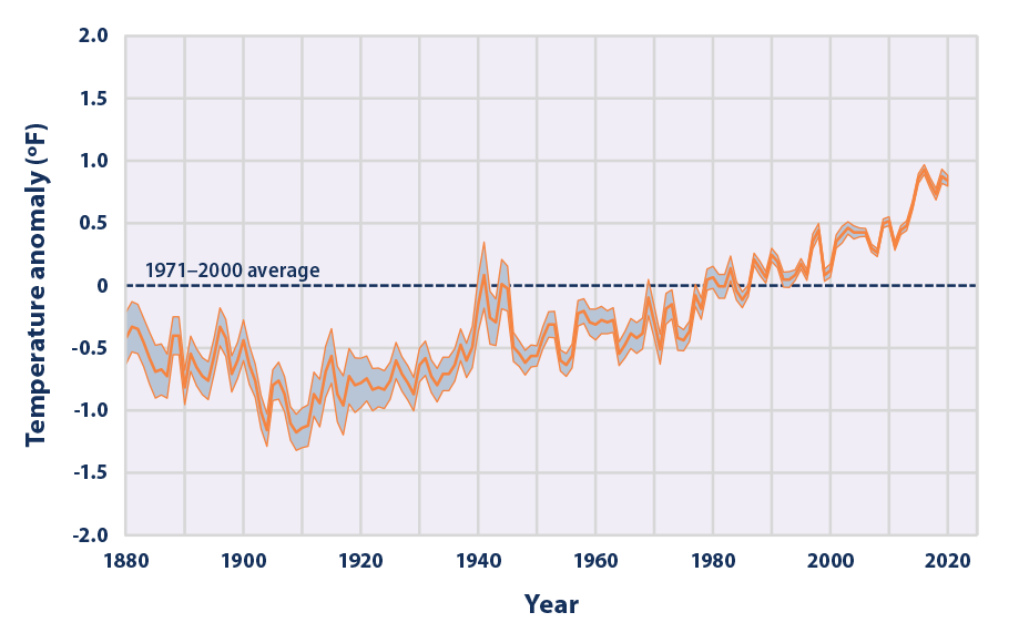 www.epa.gov
 climate 1880 indicators temp epa
Global-Atlantic Surface Temperature On Friday 17 Sep At 12pm UTC
 www.weather-forecast.com
 atlantic global temperature surface map weather utc 12pm sep friday hours
Atlantic Tropical Season Heating Up – Finger Lakes Weather
 flxweather.com
 atlantic sst sea temperature surface ocean anomaly temperatures analysis north noaa weather charts tropical anomalies heating season nhc water meteorological
Mean Annual Sea Surface Temperature, 1854-2012, Averaged Across The... | Download Scientific Diagram
 www.researchgate.net
 surface 1854 averaged
6.2 Temperature – Introduction To Oceanography
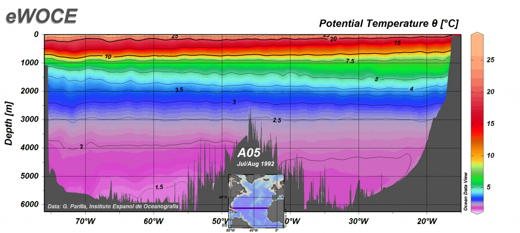 rwu.pressbooks.pub
 thermocline oceanography figure6 rwu pressbooks
Sea Surface Temperature | Indian Ocean Cyclone Tracking | HurricaneZone
 www.hurricanezone.net
 temperature sea surface global noaa sst ocean contour analysis cyclone
(A) False-color Image Of Sea Surface Temperature During The Atlantic... | Download Scientific
 www.researchgate.net
 meridional false transect
How Does Water Temperature Affect Tropical Systems?
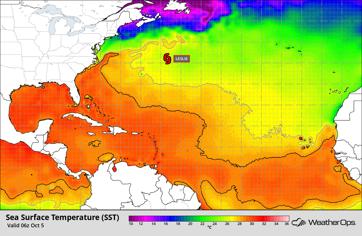 blog.weatherops.com
 temperature atlantic water sea surface temperatures tropical ocean map does weather affect systems hurricane factors whether
A Marine Heatwave Is Warming Up The Ocean Along The East Coast | Here & Now
 www.wbur.org
 heatwave hurricane anomalies tidbits heat courtesy sea snowbrains
Thermocline oceanography figure6 rwu pressbooks. Main ocean currents and sea surface temperatures in the north atlantic.... Mean annual sea surface temperature, 1854-2012, averaged across the...


Comments
Post a Comment